An avalanche forecasting tool might look a little bit different when you are planning your next big adventure into the backcountry.
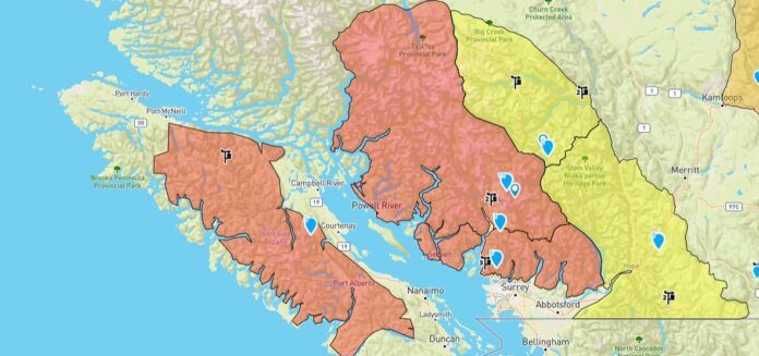
Avalanche Canada’s new flexible forecast system means that forecast regions are dynamic and have boundaries that change in response to conditions, according to the forecaster.
They say regions affected by weather systems or existing avalanche problems can be separated from areas that are not affected. This means more forecasts can be done to reflect changes from area to area, rather than having fixed forecast regions or region names.
Avalanche Canada field technician and forecaster Colin Garritty says the new system will make it easier to communicate changes on Vancouver Island.
“We split the Island into four sub-regions, we have south, north, east and west Island sub-regions,” said Garritty.
“Typical variability that we’d see across the island is much greater precipitation amounts closer to the west coast, generally we have lower elevation terrain and warmer temperatures towards the south and the north of the region doesn’t always see the same storms that we see further south.
“East island maybe falls in kind of a happy medium between these other ones and also sees the greatest amount of traffic from our users.”
Garritty says the forecast format is still the same as it was before, but the areas are now coloured rather than having an icon. He adds a location search option allows people to find the closest reports for the area they are heading to.
The forecast is a very important tool when looking to plan their next backcountry adventure, according to Garritty.
“What users will find now is that when they’re looking at a forecast product, they might not have to drill in so deeply into the forecast to see how conditions might vary over the region,” said Garritty.
As of Wednesday afternoon, most of Vancouver Island and the south coast is at a high avalanche risk. Garritty says with the new snow, it is now “above threshold” where there is more snow than what can be held by the ground.
“As soon as we get that smooth surface happening, it can even be a rock slab and you’re at threshold at 30 centimetres,” said Garrity. “But once the snowpack forms that smooth surface generally then everything transforms into avalanche territory quite quickly.”
Comox Valley Search and Rescue search manager Marc Lyster says the best thing for people to do heading into the backcountry should follow the three Ts.
The three Ts include a trip plan, knowing where you are going and telling someone where you are going, having the correct avalanche training and taking the essential gear including a shovel and probe are necessary to have a safe experience.
He adds forecasts should be checked before going out to understand what conditions might be faced.


